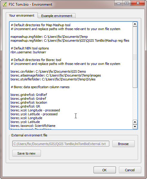
QGIS plugin environment options (version 2.8.0)
This is the help for version 2.8.0 of the FSC QGIS plugin which is the last release compatible with version 2.n.n of QGIS. If you want to see the help pages for version 3.n.n of the plugin, which is compatible with version 3.n.n of QGIS, then follow this link: FSC QGIS plugin for version 3 of QGIS.
 You can set a number of environment options to increase the ease of use and, in some cases, change the behaviour of the Tom.bio Tool for QGIS.
To set or change environment options, you start the environment options dialog by selecting plugins>TomBio productivity tools>environment options. In the your environment tab you can specify one or more options as illustrated below. Examples of many of these can be seen on the example environment tab.
Options are specified by by specifying their name, e.g. biorec.gridrefcol, followed by a colon and a space and then the value of the variable. Any line in the options file which starts with the hash symbol (#) is treated as a comment.
Tip: By default the file which records your environment options is stored in the software folder which means it gets overwritten every time the Tom.bio plugin is updated. To avoid this, you can use the save to new button at the foot of the your environment tab to save the options to a file somewhere else on your file system. Then, when you update the software, you can use the browse button to set the environment options from this file.
Biological Records Tool
The biorec.csvfolder variable can be used to specify a path to a folder which is the default used when you use the Browse button to locate a CSV file.
The biorec.atlasimagefolder variable can be used to specify a default path to the folder used for map images generated. Setting this saves you from having to re-specify it each time you open the tool.
The biorec.stylefilefolder variable can be used to specify a path to a folder which is the default used when you use the Browse to style file button to locate a style file.
The biorec.gridrefcol variable indicates the name of a spreadsheet column which will be recognised as a column specifying a grid reference and automatically selected by the tool.
The biorec.taxoncol variable indicates the name of a spreadsheet column which will be recognised as a column specifying a taxon and automatically selected by the tool.
The biorec.groupingcol variable indicates the name of a spreadsheet column which will be recognised as a column specifying a grouping column and automatically selected by the tool.
The biorec.abundancecol variable indicates the name of a spreadsheet column which will be recognised as a column specifying an abundance column and automatically selected by the tool.
Note that you can specify any of the above four column variables more than once to allow for spreadsheets of different naming conventions.
If the biorec.scientificnames variable is set to true, then the Scientific names checkbox will be checked by default.
If the biorec.maketree variable is set to true, then the tool attempts to generate the taxon tree when a spreadsheet is loaded.
If the biorec.outtrim variable is set to true, then GeoJSON atlas layers generated by the tool will have the Richness and Taxa fields removed in the interests of saving space for layers used over the internet.
The biorec.xGridOffset and biorec.yGridOffset variables (from version 2.7.0) allow you to set an offset for the origin of altas maps. Offsets are specified in the map units of the current map view CRS. Note that these variables are also used by the OSGR Tool to offset user-generated grids. An example of the kind of situation where this can be useful is in Luxembourg where biological records atlas maps are commonly made on a 5 km grid offset from the standard EPSG:2169 CRS by 3000 (easting) and 4000 (northing).
OSGR Tool
The biorec.xGridOffset and biorec.yGridOffset - allow grids to be offset from the origin of the current map view CRS (see Biological Records tool for more).
Map Mashup Tool
The mapmashup.imgfolder variable can be used to specify a default value for the path to a folder which is that used to load images from with the paste most recent image from image folder button.
The mapmashup.regfolder variable can be used to specify a default value for the path to a folder where you keep your world files. The files in this folder are used to populate the world file drop-down list.
NBN Tool
The nbn.username variable can be used to specify a default value for the NBN user name.
The nbn.password variable can be used to specify a default value for the NBN password (beware of security if you are setting this variable in your enviroment options file).


